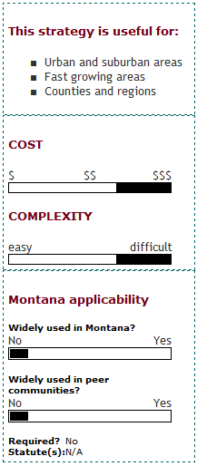

What is an Urban Growth Boundary?
Urban growth boundaries are geographic areas defined in plans or regulations as desirable and appropriate for growth during a defined period of time, usually 20 years. In order to encourage private investment, urban growth areas are considered a high priority for public infrastructure and services.
Land considered suitable for inclusion in an urban growth area usually has existing public infrastructure and/or has a high potential for cost-effective infrastructure investments. Land outside of an urban growth boundary is less suitable for development because the cost of extending public infrastructure and services would be high, because it is environmentally sensitive, and/or because preservation of its rural or natural character is important.
Who can implement an Urban Growth Boundary?
Urban growth boundaries are typically implemented through state, regional, or local planning agencies or legislative bodies. They work best when coupled with a larger comprehensive growth policy and/or subarea plans. It is also important to have an up-to-date assessment of existing public infrastructure and services.
What are the keys to success and potential pitfalls?
Stakeholder Involvement and Public Outreach: Because urban growth boundaries have a significant impact on the ability to develop private land, a thorough public involvement process is critical in formulating these boundaries. Potential controversies can be avoided during the planning stages by carefully designing these boundaries to address public, professional, and political concerns. The process for adopting and updating the boundaries should be very clear.
Technically Sound Methodology for Boundary Designation and Adjustments: Urban growth boundaries require careful analysis prior to implementation, both in terms of stakeholder input and in terms of technical analysis. It is important to use logical, defensible criteria for identifying land to be included urban growth boundaries. Planning for a 20-year urban growth boundary requires technical resources sufficient to project the locations and rates of future growth, to identify suitable locations for urban growth boundaries, and to develop infrastructure and funding plans to support the desired growth. Impact analyses should be conducted prior to implementing any growth boundary.
Consistent, Streamlined Development Review Process: The boundary should serve as an incentive for development by enabling projects in the designated areas to move forward more quickly and easily than projects outside the boundary. Toward this end, the development review process for proposed projects in the urban growth areas should be clearly defined, quickly administered and consistently applied. Ongoing administrative costs should be factored into the plans for maintaining and updating the urban growth boundary.
Where has this strategy been applied?
Examples in Montana
- The City of Missoula: In July 2009, the City of Missoula produced the first annual update of the supporting data used to create the Urban Fringe Development Area (UFDA) Growth Policy Amendment adopted in 2008. This document shows the changes to some of these factors that have occurred during the calendar year 2008.
- The City of Bozeman: The Bozeman Community Plan is based on the 20-year sewer service boundary contained in the City's 2007 Wastewater Facilities Plan. This same planning area boundary was used for other City facility plans, including the Parks, Recreation, Open Space and Trails Plan, the Water Facilities Plan, and the Stormwater Facilities Plan. It is fairly common for larger communities in Montana to base the urban planning area on the future water or wastewater service area boundary.
- The City of Kalispell also used this approach for their growth policy and the water and wastewater facilities service area (potential utility service area) was used as the boundary for their transportation plan.
Examples outside of Montana
- Metro (Portland, OR) Urban Growth Boundary: The most studied example of urban growth boundaries is that of Portland, Oregon. In the 1970's, the State of Oregon passed laws requiring every city and metropolitan area to designate an urban growth boundary. Though controversial, many have cited the urban growth boundary as a significant reason behind Portland's increases in housing density, transit and bicycle use, and air quality, while significantly limiting the expansion of sprawl into rural lands. Much of the controversy surrounds the issues of housing affordability and the impact on landowners outside of the boundary.
- The Boulder, Colorado, area has sought to control sprawl through a comparable "community service area concept".
- Lexington, KY: Kentucky's growth boundary has preserved the Bluegrass Country around Lexington since 1958.
Case studies
How can I get started?
Urban growth boundaries involve a balance of rural preservation and contained urban development. A first step toward in containing urban development would be to identify and adopt general boundaries in the local Growth Policy, followed by the development of regulatory tools and financing tools such as concurrency requirements.
Where can I get more information?
- Rolf Pendall, Jonathan Martin, and William Fulton. August 2002. Holding the Line: Urban Containment In The United States.
- Maryland Office of Planning. 1995. Models and Guidelines for Managing Maryland's Growth: Urban Growth Boundaries.
- Smart Communities Network.
- Greenbelt Alliance. "Urban Growth Boundaries"
